Guatemala - MC Grecof


Main menu:


Guatemala
Introduction |
|||||||
Flag: |
|
||||||
Card: |
|
||||||
Background: |
Guatemala was freed of Spanish colonial rule in 1821. During the second half of the 20th century, it experienced a variety of military and civilian governments as well as a 36-year guerrilla war. In 1996, the government signed a peace agreement formally ending the conflict, which had led to the death of more than 100,000 people and had created some 1 million refugees. |
||||||
Geography |
|||||||
Location: |
Middle America, bordering the Caribbean Sea, between Honduras and Belize and bordering the North Pacific Ocean, between El Salvador and Mexico |
||||||
Map references: |
Central America and the Caribbean |
||||||
Area: |
total: 108,890 sq km |
||||||
Coastline: |
400 km |
||||||
Climate: |
tropical; hot, humid in lowlands; cooler in highlands |
||||||
Terrain: |
mostly mountains with narrow coastal plains and rolling limestone plateau (Peten) |
||||||
Elevation extremes: |
lowest point: Pacific Ocean 0 m |
||||||
Landesgrenzen: |
Gesamtlänge 1.687 Kilometer. |
||||||
People |
|||||||
Population: |
12,974,361 (July 2001 est.) |
||||||
Nationality: |
noun: Guatemalan(s) |
||||||
Ethnic groups: |
Mestizo (mixed Amerindian-Spanish or assimilated Amerindian - in local Spanish called Ladino), approximately 55%, Amerindian or predominantly Amerindian, approximately 43%, whites and others 2% |
||||||
Religions: |
Roman Catholic, Protestant, indigenous Mayan beliefs |
||||||
Languages: |
Spanish 60%, Amerindian languages 40% (more than 20 Amerindian languages, including Quiche, Cakchiquel, Kekchi, Mam, Garifuna, and Xinca) |
||||||
Government |
|||||||
Country name: |
conventional long form: Republic of Guatemala |
||||||
Government type: |
constitutional democratic republic |
||||||
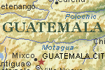
Capital: |
Guatemala |
||||||
Administrative divisions: |
22 departments (departamentos, singular - departamento); Alta Verapaz, Baja Verapaz, Chimaltenango, Chiquimula, El Progreso, Escuintla, Guatemala, Huehuetenango, Izabal, Jalapa, Jutiapa, Peten, Quetzaltenango, Quiche, Retalhuleu, Sacatepequez, San Marcos, Santa Rosa, Solola, Suchitepequez, Totonicapan, Zacapa |
||||||
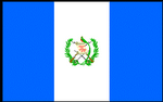
Flag description: |
three equal vertical bands of light blue (hoist side), white, and light blue with the coat of arms centered in the white band; the coat of arms includes a green and red quetzal (the national bird) and a scroll bearing the inscription LIBERTAD 15 DE SEPTIEMBRE DE 1821 (the original date of independence from Spain) all superimposed on a pair of crossed rifles and a pair of crossed swords and framed by a wreath |
||||||
Economy |
|||||||
Economy - overview: |
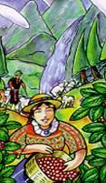
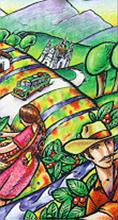
The agricultural sector accounts for about one-fourth of GDP, two-thirds of exports, and half of the labor force. Coffee, sugar, and bananas are the main products. Former President ARZU (1996-2000) worked to implement a program of economic liberalization and political modernization. The 1996 signing of the peace accords, which ended 36 years of civil war, removed a major obstacle to foreign investment. In 1998, Hurricane Mitch caused relatively little damage to Guatemala compared to its neighbors. Ongoing challenges include increasing government revenues, negotiating further assistance from international donors, and increasing the efficiency and openness of both government and private financial operations. Despite low international prices for Guatemala's main commodities, the economy grew by 3% in 2000 and is forecast to grow by 4% in 2001. Guatemala, along with Honduras and El Salvador, recently concluded a free trade agreement with Mexico and has moved to protect international property rights. However, the PORTILLO administration has undertaken a review of privatizations under the previous administration, thereby creating some uncertainty among investors. |
||||||
Industries: |
sugar, textiles and clothing, furniture, chemicals, petroleum, metals, rubber, tourism |
||||||
Agriculture - products: |
sugarcane, corn, bananas, coffee, beans, cardamom; cattle, sheep, pigs, chickens |
||||||
Currency: |
quetzal (GTQ), US dollar (USD), others allowed |
||||||
Transportation |
|||||||
Railways: |
total: 884 km (102 km privately owned) |
||||||
Ports and harbors: |
Champerico, Puerto Barrios, Puerto Quetzal, San Jose, Santo Tomas de Castilla |
||||||
Häfen: |
Champerico, Puerto Barrios, Puerto Quetzal, Santo Tomas |
||||||
Coffee |
|||||||
Qualities: |
Arabica: classified as per altitude SHB, HB, Xprime and per preparation |
||||||
Port of Export: |
Santo Tomas de Castillo, Puerto Barrios |
||||||
Shipment: |
In container in bags (275 bags each 69,- kos net) or bulk 20.7 tons |
||||||
Production: |
abt. 3.8 Mio bags |
||||||
Export figures: |
abt. 2.5 Mio bags |
||||||
Caffeine content: |
1,32 % |
||||||
Guatemala blends |
|||||||
|
|
|
|
|
|
||
Antigua Coffee |
|||||||
|
Rich volcanic soil, low humidity, lots of sun and cool nights characterize the Antigua region. The valley is dominated by the magnificent volcanoes of Agua, Acatenango and Fuego. Every once in a while, Fuego--one of Guatemala's three active volcanoes,--adds a fresh dusting of mineral rich ash to Antigua's soil. By far the driest of Guatemalas seven coffee regions, volcanic pumice in the soil retains moisture. Like all of Guatemalas specialty coffee, Antigua Coffee is cultivated under shade. In Antigua, shade is especially dense to protect the coffee trees from the regions occasional frost during the chilly nights from December to February. The dense shade combined with the regions shallow water table produce a distinct microclimate within the coffee fields |
||||||
|
Cup Characteristics |
||||||
|
Altitude: 5000-5600ft / 1500-1700m |
||||||
|
Rainfall : 32-48 in / 800-1,200 mm |
||||||
|
Drying Process: Sun |
||||||
Fraijanes Plateu |
|||||||
|
Volcanic soil filled with pumice, very high altitude and an active volcano are characteristics that Fraijanes shares with nearby Antigua. But plenty of rain, high and variable humidity, and a wider temperature range give Fraijanes a very different climate. |
||||||
|
Cup Characteristics |
||||||
|
Altitude: 4500-6000ft / 1500-2000m |
||||||
|
Rainfall : 60-120in / 1500-3000mm |
||||||
|
Drying Process: Sun |
||||||
Highland Huehue |
|||||||
|
Huehuetenango is the driest and the highest of the three non-volcanic regions producing specialty coffee. It is also by far the most rugged and remote area in Guatemala, with coffee cultivated in broken and very steep terrain. Thanks to the dry, hot winds that blow into the mountains from the Tehuantepec plain in Mexico, the region is protected from frost, allowing coffee to be cultivated up to 6,500 feet. Huehuetenangos extreme remoteness requires that virtually every producer, large or small, individual or farm, process his own coffee. Fortunately, the region has an almost infinite number of rivers and streams, so a mill can be located almost anywhere. |
||||||
|
Cup Characteristics: |
||||||
|
Altitude: 5000-6500ft / 1500-2000m |
||||||
|
Rainfall : 48-56in / 1200-1400mm |
||||||
|
Drying Process: Sun |
||||||
New Oriente |
|||||||
|
Rainy and cloudy, Oriente is similar to Cobán in climate, only less so. Located over what was once a volcano range its soil is derived from metamorphic rock. This makes it balanced in minerals and very different from Guatemala's volcanic regions, all of which have seen volcanic activity since coffee was first planted. |
||||||
|
Cup Characteristics: |
||||||
|
Altitude: 4300-5500ft / 1300-1700m |
||||||
|
Rainfall : 72-80in / 1800-2000mm |
||||||
|
Drying Process: Sun & Dryer |
||||||
Rainforest Cobán |
|||||||
|
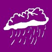
Cobán is quite different from Guatemalas other coffee regions: cloudy, rainy and cool all year-round, with soil formed from limestone and clay. Most Rainforest Cobán is cultivated on the regions distinctive rolling hills, under the tropical influences of the Atlantic Basin and the jungles to the north. Cobán has two seasons: rainy and rainier. The annual rainfall range is the second highest of the coffee growing regions, with the heaviest rains from May to December. During the rest of the year, the regions celebrated chipi-chipi frequently engulfs the region in a fine mist that falls from dense cloud cover. |
||||||
|
Cup Characteristics: |
||||||
|
Altitude: 4300-5000ft / 1300-1500m |
||||||
|
Rainfall : 120-160 in / 3000-4000 mm |
||||||
|
Drying Process: Dryer |
||||||
Traditional Atitlán |
|||||||
|
Of Guatemalas four volcanic coffee regions, Atitláns soil is the richest in organic matter. Ninety percent of Traditional Atitlán is cultivated along the slopes of the dramatic volcanoes that dominate the shores of Lake Atitlán, the largest and most famous of Guatemalas many crater lakes. The daily winds (called Xocomil) that stir the cold lake water are an important influence on this microclimate. The cultures highly developed artisan tradition is reflected in the small producers skilled cultivation and processing. Although some take their coffee to nearby farms for milling, many belong to cooperatives with their own mill, or process their harvest at home. |
||||||
|
Cup Characteristics: |
||||||
|
Altitude: 5000-5600ft / 1500-1700m |
||||||
|
Rainfall: 72-92in / 1800-2300mm |
||||||
|
Drying Process: Sun |
||||||
Volcanic San Marcos |
|||||||
|
The warmest of all of the seven coffee-growing regions, San Marcos also has the highest rainfall, the most intense rainy season, and the earliest flowering. The seasonal rains come earlier than in the other regions, arriving by mid-April and tapering off mid-November. As they build to a crescendo in June and September, they become torrential deluges, raising annual rainfall in some areas to an impressive 200 inchesby far the most of any of the coffee-growing regions, even rainy and cloudy Cobán. As in all of Guatemalas remote regions, most of the coffee is cultivated on farms with their own processing mills. Because of the unpredictability of the rain during the harvest season, much of the coffee is pre-dried in the sun and with and finished in a Guardiola dryer. |
||||||
|
Cup Characteristics: |
||||||
|
Altitude: 4600-6000ft / 1400-1800m |
||||||
|
Rainfall: 160-200in / 4000-5000mm |
||||||
|
Drying Process: Sun & Dryer |
||||||