Honduras - MC Grecof


Main menu:


Honduras
Introduction |
|||||
Flag: |
|
||||
Card: |
|
||||
Background: |
Part of Spain's vast empire in the New World, Honduras became an independent nation in 1821. After two and one-half decades of mostly military rule, a freely elected civilian government came to power in 1982. During the 1980s, Honduras proved a haven for anti-Sandinista contras fighting the Marxist Nicaraguan Government and an ally to Salvadoran Government forces fighting against leftist guerrillas. |
||||
Geography |
|||||
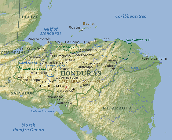
Location: |
Middle America, bordering the Caribbean Sea, between Guatemala and Nicaragua and bordering the North Pacific Ocean, between El Salvador and Nicaragua |
||||
Geographic coordinates: |
15 00 N, 86 30 W |
||||
Map references: |
Central America and the Caribbean |
||||
Area: |
total: 112,090 sq km |
||||
Climate: |
subtropical in lowlands, temperate in mountains |
||||
Terrain: |
mostly mountains in interior, narrow coastal plains |
||||
Elevation extremes: |
lowest point: Caribbean Sea 0 m |
||||
People |
|||||
Population: |
6,406,052 |
||||
Nationality: |
noun: Honduran(s) |
||||
Ethnic groups: |
mestizo (mixed Amerindian and European) 90%, Amerindian 7%, black 2%, white 1% |
||||
Religions: |
Roman Catholic 97%, Protestant minority |
||||
Languages: |
Spanish, Amerindian dialects |
||||
Government |
|||||
Country name: |
conventional long form: Republic of Honduras |
||||
Government type: |
democratic constitutional republic |
||||
Capital: |
Tegucigalpa |
||||
Administrative divisions: |
18 departments (departamentos, singular - departamento); Atlantida, Choluteca, Colon, Comayagua, Copan, Cortes, El Paraiso, Francisco Morazan, Gracias a Dios, Intibuca, Islas de la Bahia, La Paz, Lempira, Ocotepeque, Olancho, Santa Barbara, Valle, Yoro |
||||
Independence: |
15 September 1821 (from Spain) |
||||
National holiday: |
Independence Day, 15 September (1821) |
||||
Constitution: |
11 January 1982, effective 20 January 1982; amended 1995 |
||||
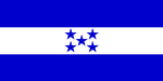
Flag description: |
three equal horizontal bands of blue (top), white, and blue with five blue five-pointed stars arranged in an X pattern centered in the white band; the stars represent the members of the former Federal Republic of Central America - Costa Rica, El Salvador, Guatemala, Honduras, and Nicaragua; similar to the flag of El Salvador, which features a round emblem encircled by the words REPUBLICA DE EL SALVADOR EN LA AMERICA CENTRAL centered in the white band; also similar to the flag of Nicaragua, which features a triangle encircled by the word REPUBLICA DE NICARAGUA on top and AMERICA CENTRAL on the bottom, centered in the white band |
||||
Economy |
|||||
Economy - overview: |
Honduras, one of the poorest countries in the Western Hemisphere, is banking on expanded trade privileges under the Enhanced Caribbean Basin Initiative and on debt relief under the Heavily Indebted Poor Countries (HIPC) initiative. While reconstruction from 1998's Hurricane Mitch is at an advanced stage, and the country has met most of its macroeconomic targets, it failed to meet the IMF's goals to liberalize its energy and telecommunications sectors. Economic growth has rebounded nicely since the hurricane and should continue in 2001. |
||||
Budget: |
revenues: $607 million |
||||
Industries: |
sugar, coffee, textiles, clothing, wood products |
||||
Agriculture - products: |
bananas, coffee, citrus; beef; timber; shrimp |
||||
Currency: |
lempira |
||||
Currency code: |
HNL |
||||
Transportation |
|||||
Railways: |
total: 595 kmnarrow gauge: 349 km 1.067-m gauge; 246 km 0.914-m gauge (1999) |
||||
Highways: |
total: 15,400 km |
||||
Waterways: |
465 km (navigable by small craft) |
||||
Ports and harbors: |
La Ceiba, Puerto Castilla, Puerto Cortes, San Lorenzo, Tela, Puerto Lempira |
||||
Coffee |
|||||
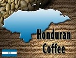
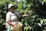
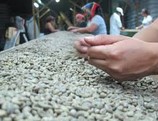
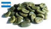
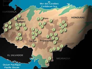
Honduran coffee is absent from the top ranks of the Speciality market for uncertain reasons. It has all the environmental factors on its side: soil, altitude, climate. All it's neighbours have sophisticated coffee production: Guatemala, El Salvador and Nicaragua. But what is lacking is infrastructure, capital and a distinct "name" in the consumer market. This means that even a good quality Honduran does not fetch a good price (and in fact many from Copan and Santa Barbara districts are smuggled into Guatemala and sold as such). Without a premium price for quality, the incentive for the farmer, the miller and the exporter have no incentive to incur the added expense that would realize the coffee's potential. So Honduran coffee ends up as a good mild blender, and not as a single-origin or farm-specific coffee. It is, clearly, a vicious cycle.Coffee is processed through the towns of Marcala or Tegucigalpa. The largest growing region is Santa Barbara, followed by El Paraiso and Comayagua. |
|||||
|
|
|
|
||
Growing-areas: |
Santa Barbara, EL Paraiso, Comayagua, Coban, Choluteca, Marcala |
||||
|
|||||
Qualities: |
washed Arabicas classified by altitude and defects (preparation) |
||||
Altitute: |
700 to 2.000 meter |
||||
Harvest: |
October to March |
||||
Shippingperiod: |
end November to July |
||||
Port of Export: |
Puerto Cortes, Amapala |
||||
Shipment: |
In container in bags (275 of each 69 kos net) or in bulk 20.7 tons |
||||
Production: |
2.500.000 bags |
||||
Export figures: |
2.194 523 bags |
||||
Caffeine content: |
1,32 % |
||||