Zambia - MC Grecof


Main menu:


Zambia
Introduction |
|||
Flag: |
|
||
Card: |
|
||
Background: |
The territory of Northern Rhodesia was administered by the South Africa Company from 1891 until takeover by the UK in 1923. During the 1920s and 1930s, advances in mining spurred development and immigration. The name was changed to Zambia upon independence in 1964. In the 1980s and 1990s, declining copper prices and a prolonged drought hurt the economy. Elections in 1991 brought an end to one-party rule, but the subsequent vote in 1996 saw blatant harassment of opposition parties. |
||
Geography |
|||
Location: |
Southern Africa, east of Angola |
||
Coordinates: |
15° 00' S, 30° 00' E |
||
Map references: |
Africa |
||
Area: |
total: 752,614 sq km |
||
Land boundaries: |
total: 5,664 km |
||
Coastline: |
0 km (landlocked) |
||
Maritime claims: |
none (landlocked |
||
Climate: |
tropical; modified by altitude; rainy season (October to April) |
||
Terrain: |
mostly high plateau with some hills and mountains |
||
Elevation extremes: |
lowest point: Zambezi river 329 m |
||
Geography - note |
Landlocked |
||
People |
|||
Population: |
9,770,199 |
||
Note: |
estimates for this country explicitly take into account the effects of excess mortality due to AIDS; this can result in lower life expectancy, higher infant mortality and death rates, lower population and growth rates, and changes in the distribution of population by age and sex than would otherwise be expected (July 2001 est.) |
||
Nationality: |
noun: Zambian(s) |
||
Ethnic groups: |
African 98.7%, European 1.1%, other 0.2% |
||
Religions: |
Christian 50%-75%, Muslim and Hindu 24%-49%, indigenous beliefs 1% |
||
Languages: |
English (official), major vernaculars - Bemba, Kaonda, Lozi, Lunda, Luvale, Nyanja, Tonga, and about 70 other indigenous languages |
||
Government |
|||
Country name: |
conventional long form: Republic of Zambia |
||
Government type: |
Republic |
||
Capital: |
Lusaka |
||
Administrative divisions: |
9 provinces; Central, Copperbelt, Eastern, Luapula, Lusaka, Northern, North-Western, Southern, Western |
||
Independence: |
24 October 1964 (from UK) |
||
National holiday: |
Independence Day, 24 October (1964) |
||
Constitution: |
2 August 1991 |
||
Flag description: |
green with a panel of three vertical bands of red (hoist side), black, and orange below a soaring orange eagle, on the outer edge of the flagUnabhängigkeitstag, 24. Oktober 1964 |
||
Economy |
|||
Economy - overview: |
Despite progress in privatization and budgetary reform, Zambia's economy has a long way to go. Privatization of government-owned copper mines relieved the government from covering mammoth losses generated by the industry and greatly improved the chances for copper mining to return to profitability and spur economic growth. In late 2000, Zambia was determined to be eligible for debt relief under the Heavily Indebted Poor Countries (HIPC) initiative. Inflation and unemployment rates remain high, but the GDP growth rate should rise in 2001. |
||
Budget- revenues: |
$900 million |
||
Industries: |
copper mining and processing, construction, foodstuffs, beverages, chemicals, textiles, fertilizer |
||
Agriculture - products: |
corn, sorghum, rice, peanuts, sunflower seed, vegetables, flowers, tobacco, cotton, sugarcane, cassava (tapioca); cattle, goats, pigs, poultry, milk, eggs, hides; coffee |
||
Currency: |
Zambian kwacha (ZMK) |
||
Currency code: |
ZMK |
||
Transportation |
|||
Railways: |
2,164 km (1995) |
||
Highways: |
total: 66,781 km |
||
Waterways: |
2.250 km |
||
Note: |
includes Lake Tanganyika and the Zambezi and Luapula river |
||
Pipelines: |
crude oil 1,724 km |
||
Ports and harbors: |
Mpulungu |
||
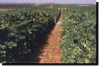
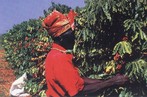
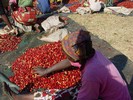
Coffee |
|||
|
|
|
|
From the country formerly known as upper Rhodesia in a country now named for the Zambezi River, Zambian coffees range from Kenya-like brightness to subtle, balanced coffee with complexity, body and nuanced flavours... Zambia has variable quality: it has the potential to be outstanding, and it can be very off-tasting and defective. |
|||