Venezuela - MC Grecof


Main menu:


Venezuela
Introduction |
||
Flag: |
|
|
Card: |
|
|
Background: |
Venezuela was one of the three countries that emerged from the collapse of Gran Colombia in 1830 (the others being Colombia and Ecuador). For most of the first half of the 20th century, Venezuela was ruled by generally benevolent military strongmen, who promoted the oil industry and allowed for some social reforms. Democratically elected governments have held sway since 1959. Current concerns include: drug-related conflicts along the Colombian border, increasing internal drug consumption, overdependence on the petroleum industry with its price fluctuations, and irresponsible mining operations that are endangering the rain forest and indigenous peoples. |
|
Geography |
||
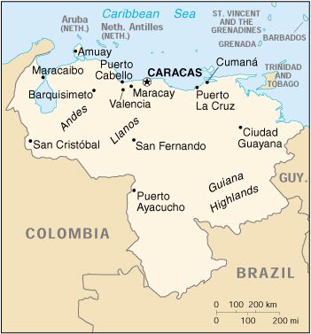
Location: |
Northern South America, bordering the Caribbean Sea and the North Atlantic Ocean, between Colombia and Guyana |
|
Geographic coordinates: |
8 00 N, 66 00 W |
|
Map references: |
South America, Central America and the Caribbean |
|
Area: |
total: 912,050 sq km |
|
Land boundaries: |
total: 4,993 km |
|
Coastline: |
2,800 km |
|
Climate: |
tropical; hot, humid; more moderate in highlands |
|
Terrain: |
Andes Mountains and Maracaibo Lowlands in northwest; central plains (llanos); Guiana Highlands in southeast |
|
Elevation extremes: |
lowest point: Caribbean Sea 0 m |
|
Natural resources: |
petroleum, natural gas, iron ore, gold, bauxite, other minerals, hydropower, diamonds |
|
Land use: |
arable land: 4% |
|
Irrigated land: |
1,900 sq km (1993 est.) |
|
Natural hazards: |
subject to floods, rockslides, mudslides; periodic droughts |
|
Geography - note: |
on major sea and air routes linking North and South America |
|
People |
||
Population: |
23,916,810 (July 2001 est.) |
|
Nationality: |
noun: Venezuelan(s) |
|
Ethnic groups: |
Spanish, Italian, Portuguese, Arab, German, African, indigenous people |
|
Religions: |
nominally Roman Catholic 96%, Protestant 2%, other 2% |
|
Languages: |
Spanish (official), numerous indigenous dialects |
|
Government |
||
Country name: |
conventional long form: Bolivarian Republic of Venezuela |
|
Government type: |
federal republic |
|
Capital: |
Caracas |
|
National holiday: |
Independence Day, 5 July (1811) |
|
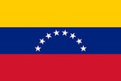
Flag description: |
three equal horizontal bands of yellow (top), blue, and red with the coat of arms on the hoist side of the yellow band and an arc of seven white five-pointed stars centered in the blue band |
|
Economy |
||
Economy - overview: |
The petroleum sector dominates the economy, accounting for roughly a third of GDP, around 80% of export earnings, and more than half of government operating revenues. Venezuelan officials estimate that GDP grew by 3.2% in 2000. A strong rebound in international oil prices fueled the recovery from the steep recession in 1999. Nevertheless, a weak nonoil sector and capital flight undercut the recovery. The bolivar is widely believed to be overvalued by as much as 50%. The government is still rebuilding after massive flooding and landslides in December 1999 caused an estimated $15 billion to $20 billion in damage. |
|
Industries: |
petroleum, iron ore mining, construction materials, food processing, textiles, steel, aluminum, motor vehicle assembly |
|
Agriculture - products: |
corn, sorghum, sugarcane, rice, bananas, vegetables, coffee; beef, pork, milk, eggs; fish |
|
Currency: |
bolivar |
|
Currency code: |
VEB |
|
Transportation |
||
Railways: |
total: 584 km (248 km privately owned) |
|
Highways: |
total: 96,155 km |
|
Waterways: |
7,100 km |
|
Ports and harbors: |
Amuay, Bajo Grande, El Tablazo, La Guaira, La Salina, Maracaibo, Matanzas, Palua, Puerto Cabello, Puerto la Cruz, Puerto Ordaz, Puerto Sucre, Punta Cardon |
|
Coffee |
||
Growing-areas: |
South-west of the Andes Tachira, Merida central Miranda |
|
Qualities: |
mainly washed Arabicas, classified as per preparation |
|
Altitude: |
400 to 1.800 meter |
|
Harvest: |
September to March |
|
Shippingperiod: |
November to April |
|
Port of Export: |
Maracaibo |
|
Shipment: |
in container in bags (300/250 each 60.- kos net each) |
|
Production: |
1.070.000 bags |
|
Export figures: |
78.315 bags |
|
Caffeine content: |
1,35 % |
|