Philipines - MC Grecof


Main menu:


Philipines
Introduction |
|||
Flag: |
|
||
Card: |
|
||
Background: |
The Philippines were ceded by Spain to the US in 1898 following the Spanish-American War. They attained their independence in 1946 after being occupied by the Japanese in World War II. The 21-year rule of Ferdinand MARCOS ended in 1986 when a widespread popular rebellion forced him into exile. In 1992, the US closed down its last military bases on the islands. The Philippines has had two electoral presidential transitions since Marcos' removal by "people power." In January 2001, the Supreme Court declared Joseph ESTRADA unable to rule in view of mass resignations from his government and administered the oath of office to Vice President Gloria MACAPAGAL-ARROYO as his constitutional successor. The government continues to struggle with ongoing Muslim insurgencies in the south. |
||
Geography |
|||
Location: |
Southeastern Asia, archipelago between the Philippine Sea and the South China Sea, east of Vietnam |
||
Coordinates: |
13° 00' N, 122° 00' E |
||
Map references: |
Südostasien |
||
Area: |
total: 300,000 sq km |
||
Land boundaries: |
0 km |
||
Coastline: |
36.289 km |
||
Climate: |
tropisches Klima; Nordostmonsun (November bis April); Südwestmonsun (Mai bis Oktober) |
||
Terrain: |
mostly mountains with narrow to extensive coastal lowlands |
||
Elevation extremes: |
lowest point: Philippine Sea 0 m |
||
Natural resources: |
timber, petroleum, nickel, cobalt, silver, gold, salt, copper |
||
Land use: |
arable land: 19% |
||
Irrigated land: |
15,800 sq km (1993 est.) |
||
Natural hazards: |
astride typhoon belt, usually affected by 15 and struck by five to six cyclonic storms per year; landslides; active volcanoes; destructive earthquakes; tsunamis |
||
People |
|||
Population: |
82.841.518 (July 2001 est.) |
||
Nationality: |
noun: Filipino(s) |
||
Ethnic groups: |
Christian Malay 91.5%, Muslim Malay 4%, Chinese 1.5%, other 3% |
||
Religions: |
Roman Catholic 83%, Protestant 9%, Muslim 5%, Buddhist and other 3% |
||
Languages: |
two official languages - Filipino (based on Tagalog) and English, eight major dialects - Tagalog, Cebuano, Ilocan, Hiligaynon or Ilonggo, Bicol, Waray, Pampango, and Pangasinense |
||
Government |
|||
Country name: |
conventional long form: Republic of the Philippines |
||
Government type: |
Republic |
||
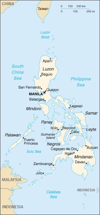
Capital: |
Manila |
||
National holiday: |
Independence Day (from Spain), 12 June (1898); note - 12 June 1898 is the date of independence from Spain, 4 July 1946 is the date of independence from the US |
||
Constitution: |
2 February 1987, effective 11 February 1987 |
||
Flag description: |
two equal horizontal bands of blue (top) and red with a white equilateral triangle based on the hoist side; in the center of the triangle is a yellow sun with eight primary rays (each containing three individual rays) and in each corner of the triangle is a small yellow five-pointed star |
||
Economy |
|||
Economy - overview: |
In 1998 the Philippine economy - a mixture of agriculture, light industry, and supporting services - deteriorated as a result of spillover from the Asian financial crisis and poor weather conditions. Growth fell to about -0.5% in 1998 from 5% in 1997, but recovered to about 3% in 1999 and 3.6% in 2000. The government has promised to continue its economic reforms to help the Philippines match the pace of development in the newly industrialized countries of East Asia. The strategy includes improving infrastructure, overhauling the tax system to bolster government revenues, moving toward further deregulation and privatization of the economy, and increasing trade integration with the region. |
||
Agriculture - products: |
rice, coconuts, corn, sugarcane, bananas, pineapples, mangoes; pork, eggs, beef; fish |
||
Currency: |
Philippinischer Peso (PHP) |
||
Currency code: |
PHP |
||
Transportation |
|||
Railways: |
total: 492 km (an additional 405 km are not in operation) |
||
Ports and harbors: |
Batangas, Cagayan de Oro, Cebu, Davao, Guimaras Island, Iligan, Iloilo, Jolo, Legaspi, Manila, Masao, Puerto Princesa, San Fernando, Subic Bay, Zamboanga |
||
Coffee |
|||
Growing-areas: |
Luzon Islan, Insel Mindanao |
||
Qualities: |
Robusta unwashed: |
Grad I (Superior) Maximum 6 % by weight |
|
Harvest: |
December to March |
||
Shippingperiod: |
January to April |
||
Port of Export: |
Manila |
||
Shipment: |
in container in bags (285/300 bags of abt. 60,- kos net) |
||
Production: |
729,000 bags |
||
Export figures: |
380,000 bags |
||
Caffeine content: |
2,19 % |
||