Ivory Coast - MC Grecof


Main menu:


Ivory Coast
Introduction |
|
Flag: |
|
Card: |
|
Background: |
Close ties to France since independence in 1960, the development of cocoa production for export, and foreign investment made Cote d'Ivoire one of the most prosperous of the tropical African states. Falling cocoa prices and political turmoil, however, sparked an economic downturn in 1999 and 2000. On 25 December 1999, a military coup - the first ever in Cote d'Ivoire's history - overthrew the government led by President Henri Konan BEDIE. Presidential and legislative elections held in October and December 2000 provoked violence due to the exclusion of opposition leader Alassane OUATTARA. In October 2000, Laurent GBAGBO replaced junta leader Robert GUEI as president, ending 10 months of military rule. |
Geography |
|
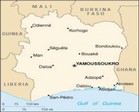
Location: |
Western Africa, bordering the North Atlantic Ocean, between Ghana and Liberia |
coordinates: |
8° 00' N, 5° 00' W |
Map references: |
Africa |
Area: |
total: 322,460 sq km |
Land boundaries: |
total: 3,110 km |
Coastline: |
515 Km |
Climate: |
tropical along coast, semiarid in far north; three seasons - warm and dry (November to March), hot and dry (March to May), hot and wet (June to October) |
Terrain: |
mostly flat to undulating plains; mountains in northwest |
Elevation extremes: |
lowest point: Gulf of Guinea 0 m |
People |
|
Population: |
16,393,221 |
Note: |
estimates for this country explicitly take into account the effects of excess mortality due to AIDS; this can result in lower life expectancy, higher infant mortality and death rates, lower population and growth rates, and changes in the distribution of population by age and sex than would otherwise be expected (July 2001 est.) |
Nationality: |
noun: Ivorian(s) |
Ethnic groups: |
Akan 42.1%, Voltaiques or Gur 17.6%, Northern Mandes 16.5%, Krous 11%, Southern Mandes 10%, other 2.8% (1998) |
Religions: |
Christian 34%, Muslim 27%, no religion 21%, animist 15%, other 3% (1998) |
Languages: |
French (official), 60 native dialects with Dioula the most widely spoken |
Government |
|
Country name: |
conventional long form: Republic of Cote d'Ivoire |
Government type |
republic; multiparty presidential regime established 1960 |
Capital: |
Yamoussoukro; note - although Yamoussoukro has been the official capital since 1983, Abidjan remains the administrative center; the US, like other countries, maintains its Embassy in Abidjan |
National holiday: |
Independence Day, 7 August (1960) |
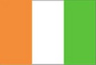
Flag description: |
three equal vertical bands of orange (hoist side), white, and green; similar to the flag of Ireland, which is longer and has the colors reversed - green (hoist side), white, and orange; also similar to the flag of Italy, which is green (hoist side), white, and red; design was based on the flag of France |
Economy |
|
Economy - overview: |
Cote d'Ivoire is among the world's largest producers and exporters of coffee, cocoa beans, and palm oil. Consequently, the economy is highly sensitive to fluctuations in international prices for these products and to weather conditions. Despite government attempts to diversify the economy, it is still largely dependent on agriculture and related activities, which engage roughly 68% of the population. After several years of lagging performance, the Ivorian economy began a comeback in 1994, due to the 50% devaluation of the CFA franc and improved prices for cocoa and coffee, growth in nontraditional primary exports such as pineapples and rubber, limited trade and banking liberalization, offshore oil and gas discoveries, and generous external financing and debt rescheduling by multilateral lenders and France. Moreover, government adherence to donor-mandated reforms led to a jump in growth to 5% annually in 1996-99. Growth was negative in 2000 because of the difficulty of meeting the conditions of international donors, continued low prices of key exports, and post-coup instability. In 2001-02, a moderate rebound in the cocoa market could boost growth back above 3%; however, political instability could impede growth again. |
Agriculture - products: |
coffee, cocoa beans, bananas, palm kernels, corn, rice, manioc (tapioca), sweet potatoes, sugar, cotton, rubber; timber |
Currency: |
Communaute Financiere Africaine franc (XOF) |
Note: |
responsible authority is the Central Bank of the West African States |
Währungcode: |
OXF |
Transportation |
|
Railways: |
total: 660 km |
Highways: |
total: 50,400 km |
Waterways: |
980 km (navigable rivers, canals, and numerous coastal lagoons) |
Ports and harbors: |
Abidjan, Aboisso, Dabou, San-Pedro |
Coffee |
|
Growing-areas: |
Southern half of the country in practically all of the forest area up to the edge of the savannah |
Qualities: |
Robusta classified as per defects and beansize |
Altitude: |
100 bis 400 meter |
Shippingperiod: |
throughout the year |
Port of Export: |
Abidjan |
Shipment: |
in containers in bags (300 of abt 60.- kos net each) |
Production: |
3,433,00 bags |
Export figures: |
2,194,381 bags |
Caffeine content: |
2.27 / 2.70 % |
Belongs to the better type of Robusta, but rather expensive |
|